Oct 26, 2015 | Blog
Environmental Cleanup Actions
The United States Department of Agriculture Forest Service begins this month an environmental cleanup of the Lead Queen Abandoned Mine (Site) situated within the Harshaw Creek watershed. The Site is located approximately six miles south of Patagonia, Arizona, within the Sierra Vista Ranger District of the Coronado National Forest and is only accessed by 4×4 or high clearance vehicles.
The objective of this cleanup is to reduce or eliminate the downstream movement of waste rock containing elevated concentrations of arsenic, lead, and other heavy metals, as well as acid mine drainage to Harshaw Creek.
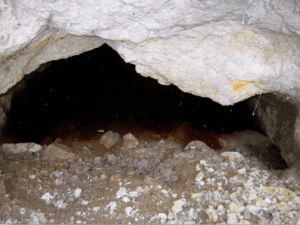
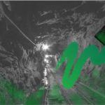
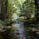
Lead Queen Adit
Past mining activities left behind abandoned horizontal openings (adits) and vertical openings (shafts), and littered the landscape with waste rock material.
The Forest Service hired an environmental firm to perform the cleanup and work should be completed by mid-February 2016. Environmental Cost Management, Inc (ECM) from California was hired for the amount of $361,689.58 of taxpayers’ money to clean up the abandoned mine site on public land.
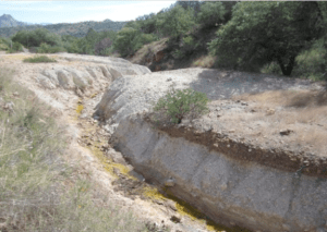
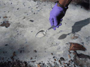
Lead Queen waste rock
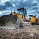
The cleanup involves construction activities using heavy equipment to consolidate waste rock into a single underground contained area, cap the waste rock with native soil, and seal 4 of 6 mine openings such as adits and shafts. Polyurethane Foam (PUF) will be used to seal two adits and two shafts. The final PUF face will be covered with clean local soil and rock to prevent UV light degradation of the foam. The other two mine openings will be closed using bat-friendly gates.
In some areas of the Site, adits and shafts serve as conduits carrying large amounts of tunnel water which potentially cause floods in the downstream channels. Storm runoff carries concentrations of heavy metals stored in these adits and shafts on the surface.
Scope of Work
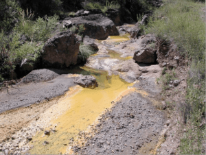
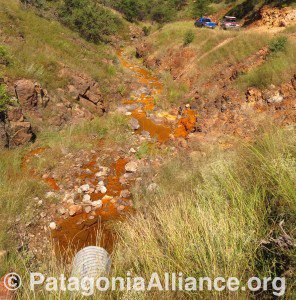
Lead Queen toxic, heavy metal drainage
The Site Cleanup will consist of excavating waste rock, hauling and placing waste rock material in a consolidation area, constructing a series of gabion walls, improving existing road for equipment access, constructing temporary access roads to mines, closing mine features, installing bat- friendly gates, and seeding and mulching of all disturbed areas.
A series of gabion walls will mitigate the transport of aluminum precipitate and red-orange sludge and sediment downstream of the Site and into the lower reaches of the Harshaw Creek watershed. These gabion walls will be installed in the drainage bottom at various locations downstream of the Site.
CERCLA Time Critical Action Removal Action
Sampling at Lead Queen mine site
The Forest Service is exercising its authority under the Comprehensive Environmental Response, Compensation, and Liability Act (CERCLA; 42 U.S.C. 9601 et seq.) to conduct the cleanup activities at the Site. The Time Critical Removal Action Approval Memorandum documents and explains the commencement of a CERCLA Removal Action at the Site. The Forest Service’s role is to protect the public health and welfare and the environment and to respond to a hazardous substance release on lands under the jurisdiction of the Forest Service, pursuant to the authority found in 42 U.S.C. 9604(a), Executive Order 12580, and 7 C.F.R. 2.60(a)(39).
Public Information
For additional information about the cleanup, please contact:
Eli Curiel Jr., P.E.,
Project On-Scene Coordinator
USDA Forest Service
Coronado National Forest
300 West Congress Street Tucson, AZ 85701
(520) 388-8413
Monday-Friday, 9:00 AM – 4:30 PM

Related links:
Forest Service Outlines Clean Up Plans for Abandoned Lead Queen Mine https://www.patagoniaalliance.org/forest-service-outlines-clean-up-plans-for-abandoned-lead-queen-mine/
Video: Leaking Historic Patagonia, Arizona Mines https://youtu.be/uEgaFhT5RXw
The U.S. Department of Agriculture (USDA) prohibits discrimination in all its programs and activities on the basis of race, color, national origin, age, disability, and where applicable, sex, marital status, familial status, parental status, religion, sexual orientation, genetic information, political beliefs, reprisal, or because all or part of an individual’s income is derived from any public assistance program. (Not all prohibited bases apply to all programs.) Persons with disabilities who require alternative means for communication of program information (Braille, large print, audiotape, etc.) should contact USDA’s TARGET Center at (202) 720-2600 (voice and TTY). To file a complaint of discrimination, write to USDA, Director, Office of Civil Rights, 1400 Independence Avenue, SW, Washington, DC 20250-9410 or call (800) 795-3272 (voice) or (202) 720-6382 (TTY). USDA is an equal opportunity provider and employer.
Feb 13, 2015 | Blog
FOR IMMEDIATE RELEASE
Regional Forester Issues Time Critical Removal Action Approval Memo
Patagonia, Arizona – Yesterday, the Southwestern Regional Office of the US Forest Service issued an Action Memo for “Time Critical” clean up of the abandoned Lead Queen mine in the Patagonia Mountains on the Coronado National Forest, approximately 6 miles south of the town of Patagonia, Arizona.
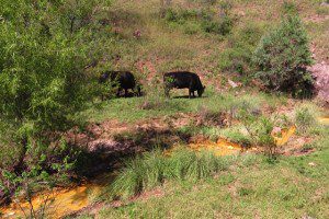
Members of the Patagonia Area Resource Alliance (PARA) discovered the abandoned mine over-flowing with toxic, orange sludge into a tributary of Harshaw Creek, last September. PARA documented the spill and notified authorities. The Harshaw Creek tributary eventually flows into the Town of Patagonia, Sonoita Creek and Patagonia Lake.
As the land owners of the Lead Queen mine, the Forest Service was issued two Notice of Violations from the Arizona Department of Environmental Quality: “Addition of a pollutant to navigable waters from a point source without a permit,” and “Discharge of storm water associated with an industrial activity without a permit.”
 Test results showed off-the-chart concentrations of lead and arsenic in water, soil and waste rock samples at the Lead Queen site. High concentrations of zinc, copper and aluminum were also found. All of these heavy metals are listed as “hazardous substances” and can cause serious – or even deadly – health issues. The red-orange color of the sludge was due to extreme concentrations of iron.
The USFS document stated the clean up aims to reduce potential exposure of the hazardous heavy metals to “human populations, animals or the food chain.”
“This is a good start, but I’ve seen many more abandoned mines in the Patagonia Mountains that also need to be cleaned up. The mining industry has a well-earned reputation for just walking away from mines when they’re done.” Gooch Goodwin, native Patagonian and PARA board member.
 The Forest Service document also acknowledges that the “Patagonia Mountains have high levels of biodiversity and are home to a variety of species protected under the Endangered Species Act including jaguar, ocelot, lesser long-nosed bat, Mexican spotted owl, western yellow-billed cuckoo, Sonora tiger salamander, and the northern Mexican gartersnake.”
It additionally states, “the area is best-known and most popular places for birding in the U.S. Bird enthusiast who come from all over the world to catch a glimpse of more than 300 species of birds, including many Neotropical species that migrate, nest, and live in this unique habitat.”
Clean up of the five acre site is expected to start Spring 2015 and be completed before the coming monsoon season to avoid erosion and flushing of heavy metals further downstream.
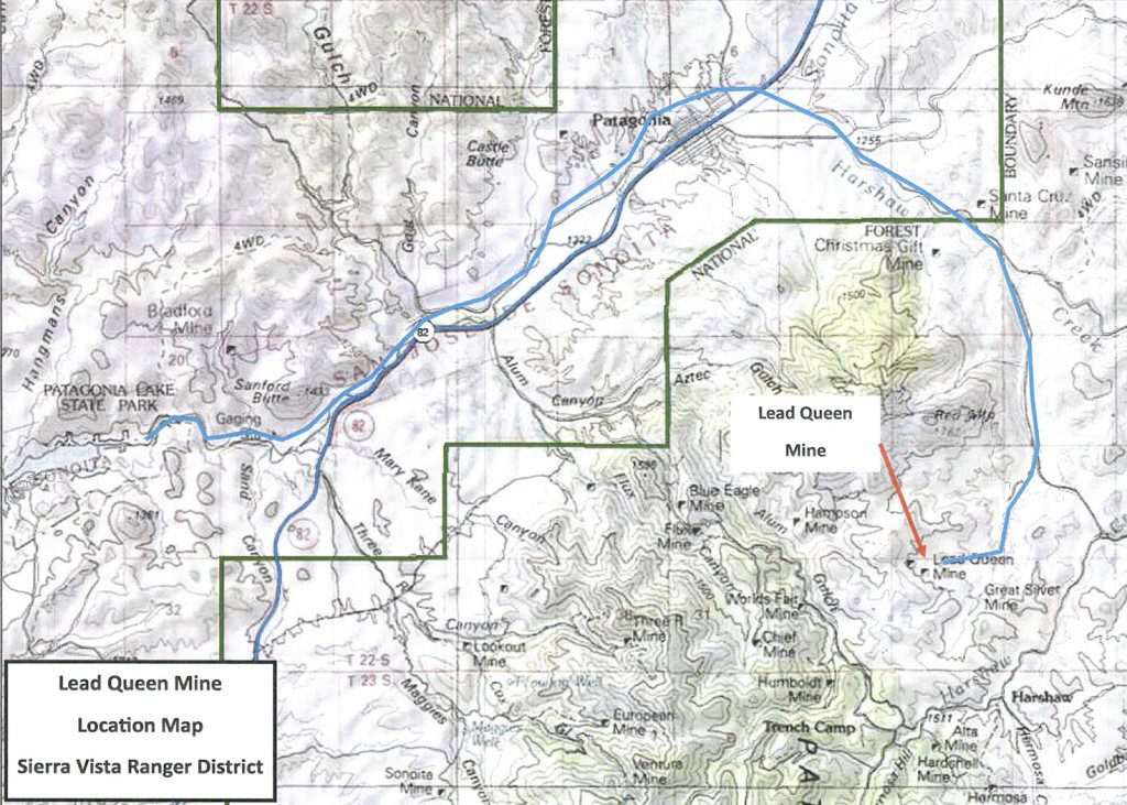
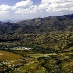
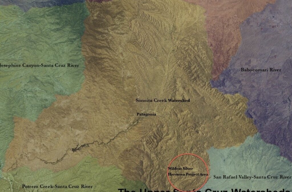
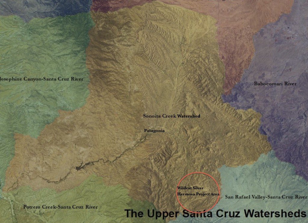
USFS map of Lead Queen mine location
Read USFS Lead Queen Mine Removal Action Memorandum
For further information regarding the USFS Removal Action Memorandum, please contact Eli Curiel, P.E., On-Scene Coordinator, at 520-388-8413; or Maria McGaha, P.E., Regional Environmental Engineer, at 505-842-3837.
###
The Patagonia Area Resource Alliance is a citizen watchdog organization that monitors the activities of mining companies, as well as ensures government agencies’ due diligence, to make sure their actions have long-term, sustainable benefits to our public lands, our water, and the town of Patagonia. For more information visit www.patagoniaalliance.org and follow us on Twitter @PARAalliance.

Nov 26, 2014 | Blog
It’s hard to believe that the end of the year is nearly upon us! When 2014 began, your friends, neighbors and colleagues here at the Patagonia Area Resource Alliance (PARA) were gearing up for a busy year promoting the incredible beauty, community, and natural heritage of the Town of Patagonia and the Patagonia Mountains. Little did we know what a whirlwind year it would be! The past eleven months have seemingly sped by while we have been advocating to protect this amazing place that we all treasure from the multiple threats that exploratory drilling and mining pose to our small community.
PARA was formed in 2011 to educate and engage the community about the risks and realities of mining, to promote local sustainable economies, to better understand our precious and imperiled natural resources such as clean water and wildlife, and to actively advocate for the protection of those resources in concert with Patagonia’s distinct and serene rural way of life.
You have helped us along the way this year! You have volunteered, come to public meetings, wrote letters, monitored wildlife, and participated in the NEPA process. Together, we have contributed over 2500 volunteer hours already in 2014!
It has been another amazing and transforming year for PARA, but we have so much more to do! PARA runs on a shoestring budget with the human power of an almost entirely volunteer workforce and our two person outreach team–budgeted for only 30 hours per week. We’d like to do so much more! Please consider making a donation to PARA this year to support and grow this critical work in our community.
A few of the activities and accomplishments reached this year through the contributions of all of PARA’s supporters, volunteers and partners:

Ocelot, Leopardus pardalis. photo US FWS
Holding Agencies Accountable
Filed a complaint in federal court in October with Defenders of Wildlife against the Forest Service and the Fish and Wildlife Service for their unlawful approval of the Regal Resources Sunnyside mineral drilling project in southern Arizona’s Coronado National Forest, in the Alum Gulch area of the Patagonia Mountains. The Sunnyside project approval violates environmental laws and poses a potential threat to endangered species and the safety of drinking water for Patagonia area residents. The Coronado National Forest, Patagonia Mountains and waterways in our region support some of the world’s most imperiled wildlife, including jaguar, ocelot, lesser long-nosed bat, Mexican spotted owl, and yellow-billed cuckoo.
 Educating the Community on Mining Risks
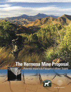
Released a peer-reviewed report with the national organization EARTHWORKS, “The Hermosa Mine: Potential Impacts to Patagonia’s Water Supply.” The report uses geologic and hydrologic studies from mine developer AZ Mining Inc (Wildcat Silver), the United States Geologic Survey, the Arizona Department of Water Resources, the Town of Patagonia, and others, as well as analyzes historic contamination issues caused by mining in the Patagonia Mountains. We conclude in our report that the seemingly inescapable realities of acid drainage and water consumption impacts pose too great a risk to Patagonia.
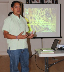
SIA Biologist, Sergio Avila
Empowering the Community, Ensuring Due Diligence
Coordinated and submitted NEPA comments on the USFS draft Environmental Assessment for the AZ Mining Inc (Wildcat Silver) Hermosa drilling project with Defenders of Wildlife, Arizona Mining Reform Coalition, Center for Biological Diversity, Earthworks, and Sky Island Alliance. Hosted a community workshop to empower residents to comment on the Hermosa EA comprising of an overview of the Hermosa proposal and its likely impacts; a NEPA presentation and how to comment on an EA by Jenny Neeley, Attorney at Law; and a presentation of area wildlife by Biologist, Sergio Avila, of Sky Island Alliance.
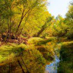
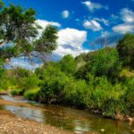
Sonoita Creek
Tireless Advocacy for Patagonia Area Water and Wildlife
Submitted comments regarding the proposed United States Forest Service Guidelines on Groundwater, advocating for groundwater protection and consideration of potential impacts regarding all agency activities in our National Forests, especially in regards to hardrock mining. Submitted comments to the Environmental Protection Agency regarding the proposed rule defining the “Waters of the U.S.” advocating for protection of ephemeral and intermittent streams. Submitted comments advocating for more designated critical habitat in the Patagonia Mountains for the threatened yellow-billed cuckoo.
To learn more about our 2014 accomplishments and efforts, please take a look at PARA’s “Report to the Community” available on our website at: www.patagoniaalliance.org/our-activities- outreach/
Looking Ahead…
Unceasing Protection of the Patagonia Mountains.
With continued legal assistance from Defenders of Wildlife, PARA strives to hold mining companies, the US Forest Service and all agencies accountable to follow the laws and regulations designed to protect our water, air, surrounding ecosystems and communities. We are positioned to respond to future exploratory mining proposals scheduled for the Patagonia Mountains.
Sustaining Wildlife Data Documentation and Collaborations
Citizen scientists from the community continue wildlife monitoring efforts in the Patagonia Mountains focusing on areas immediately at risk by proposed mining activities. Data gathered is used to fight mining proposals through species lists, presence of vulnerable species and habitat analysis. Additional collaborations are ongoing with Defenders of Wildlife, EARTHWORKS, Sky Island Alliance and Tucson Audubon to ensure this data is applied to advocacy efforts in the most effective ways.
Increasing Our Outreach for 2015
PARA is strategizing to expand community education activities to grow our base of support and empower concerned residents with potential actions to keep mining out of the Patagonia Mountains. We recognize the need to establish sustainable funding to maintain core functions and seek to expand funding sources. With our additional staff funding in the 2015 budget, we plan to sustain our two person team to continue to expand our outreach beyond our community boundaries. Our 2014 Financial Report is also available online: www.patagoniaalliance.org/our-activities-outreach/
For A Thriving Community in 2015 and beyond
PARA recognizes that the health and economic prosperity of our community are deeply connected to the well-being of the Patagonia Mountains and the Harshaw/Sonoita Creek watershed. They are the source of our drinking water, clean air and the centerpieces that drive our local economy.
Please make a Year-End Gift to PARA
There are many needs in our community and many compelling requests for support. We believe one of the most fundamental is protecting our drinking water and our community from the well-known detrimental effects of open pit mining. To that end, PARA is seeking to raise $19,000 by the end of 2014 to support the several ongoing and new initiatives outlined above as we move into 2015. We are fortunate to have a group of amazingly committed community members and generous donors supporting our work, but we are looking to broaden the base of support to ensure not only financial sustainability, but also the ability to impact local, regional and national decision-making on our own behalf.
That’s where you come in. The work necessary to make this vision of 2015 a reality is possible only because of your time and your financial support. Please make a gift today.
Recurring monthly donations can be made securely through PayPal.
Every single contribution makes a sizable difference to our organization and ultimately for our community. It is only because of the generous support from people like you that we can undertake this critical work. Thank you!
Oct 28, 2014 | Blog
Peer-reviewed report outlines Hermosa mine’s risks of water consumption, perpetual water pollution to Patagonia area
Patagonia Area Resource Alliance
Earthworks
October 28, 2014
 Patagonia – The Hermosa silver mine proposed inside Patagonia, Arizona’s Municipal Supply Watershed could deplete the town’s drinking water and perpetually contaminate area groundwater with acid mine drainage, according to a new peer-reviewed report.
Reviewed* by a USGS scientist and released by the Patagonia Area Resource Alliance and Earthworks, the study also concludes that drinking water wells of surrounding residents are also threatened.
“A mine that threatens our town’s drinking water is a mine that shouldn’t be built,” said Wendy Russell of the Patagonia Area Resource Alliance. She continued, “In Arizona, water is more precious than silver, and especially so after more than a decade of drought.”
Proposed by Canadian exploration company AZ Mining Inc (Wildcat Silver) – a company with no experience operating a mine – Hermosa is proposed at a time when Patagonia is already concerned with dropping groundwater levels and increasing concern about future water supplies.
The 4,000 foot wide and 1,500 foot deep Hermosa silver and manganese mine would consume 670 million to 1.2 billion gallons of groundwater per year – up to 53 times the amount of water the town uses today — to run the mine within the upper reaches of Harshaw Creek, a portion of Patagonia’s Municipal Supply Watershed. This water consumption will lower the recharge rates for the aquifer on which the town depends, and is also likely to produce acidic runoff, requiring ongoing treatment in perpetuity.
“If the U.S. Forest Service were to permit the Hermosa mine, this report shows it would jeopardize our community’s drinking water. And for what? For foreign shareholders’ silver,” said Wendy Russell. She continued, “This is a mine proposal that just doesn’t make sense for our community who would actually have to live with it.”
The mine is proposed within the Coronado National Forest, and therefore subject to the 1872 Mining Law. Federal land managers interpret the 1872 Mining Law to require them to permit mines, no matter if the land is better used for other purposes – like protecting a town’s drinking water supply watershed.
“Because the Hermosa mine proposal threatens area water supplies, it obviously should not be permitted,” said report author Pete Dronkers of Earthworks. He continued, “That it’s being considered at all is a strong argument for reforming the 1872 Mining Law to allow the consideration of other potential land uses.”
The report also evaluates the nature of groundwater depletion that is likely under the proposed mine plan, characterizes the impacts of such, and also analyses other known adverse impacts, such as air pollution, endangered species, and other cumulative impacts.
The report, including an executive summary, can be found at: patagoniaalliance.org/report-hermosa-mine
For more information:
Fact Sheet
Full Report
Contact:
Pete Dronkers, Earthworks
(775) 815-9936, pdronkers@earthworksaction.org
Wendy Russell, Patagonia Area Resource Alliance
(520) 477-2308, wendy@patagoniaalliance.org
* An earlier version of this press release indicated that a USGS scientist “endorsed” this report. We were informed by the United States Geological Survey that the agency only endorses their own reports and documents.
Sep 26, 2014 | Blog
FOR IMMEDIATE RELEASE
Contact: Courtney Sexton, 202.772.0253, csexton@defenders.org
Wendy Russell, 520.477.2308, Wendy@PatagoniaAlliance.org
Toxic Mining Contaminants Threaten People and Wildlife in Arizona

Bright orange water overflowing from the historic Trench mine, twice reclaimed by Asarco and now owned by the State of Arizona.
TUCSON, ARIZ. – Contaminants from a mine spill in Cananea, Sonora earlier this summer have likely reached the San Pedro River flowing into Arizona. And with recent storms, old copper and silver mine sites near Patagonia are leaking bright red contaminants into local streams. These toxic reminders of our mining history have the potential to wreak havoc on local water supplies and wildlife in the Coronado National Forest, one of the most biologically diverse areas in the world.
“The Coronado National Forest, the “Sacred” Santa Ritas, the San Pedro River Valley, the Patagonias and all of the Sky Islands nourish some of the most incredible and endangered biodiversity in the world, including jaguars, ocelots, yellow-billed cuckoos and Gila topminnows,” said Eva Sargent, director of Southwest Programs for Defenders of Wildlife. “This is a place that must be conserved, not a place for the destructive practice of mining and its toxic byproducts that ruin our public landscapes and pollute our waters.”
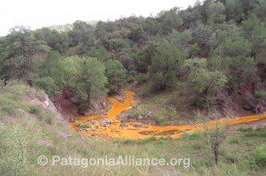
Toxic overflow from the historic Lead Queen mine in the Patagonia Mountains drains towards Harshaw Creek.
“All this toxic runoff is a prime example of why new mines should not be approved in the mountains of southern Arizona,” added Wendy Russell of the Patagonia Area Resource Alliance. “There are already approximately 130 abandoned mines in the Patagonia Mountains, many with eroding tailings and leaking tunnels discharging toxins. With heavy rainfall, that toxic discharge overflows into water systems like Harshaw Creek and Alum Gulch in the Santa Cruz watershed and threatens both local communities’ drinking water and already endangered fish and wildlife. With the state and federal governments seemingly incapable of cleaning up old polluting mines in the Patagonia Mountains, we have no confidence in their abilities to regulate new mining activity to protect our community’s drinking water, health and safety.”
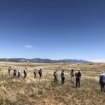
Interviews with local experts regarding abandoned mine overflows in the Patagonia Mountains of southern Arizona in September, 2014.
###
Defenders of Wildlife is dedicated to the protection of all native animals and plants in their natural communities. With more than 1.1 million members and activists, Defenders of Wildlife is a leading advocate for innovative solutions to safeguard our wildlife heritage for generations to come. For more information, visit www.defenders.org<http://www.defenders.org/> and follow us on Twitter @DefendersNews<http://twitter.com/DefendersNews>.
The Patagonia Area Resource Alliance is a citizen watchdog organization that monitors the activities of mining companies, as well as ensures government agencies’ due diligence, to make sure their actions have long-term, sustainable benefits to our public lands, our water, and the town of Patagonia. For more information visit www.patagoniaalliance.org<http://www.patagoniaalliance.org>
Apr 8, 2014 | Blog
By Bryan Junger
As a citizen of Patagonia and environmental engineer, I got a real kick out of Greg Lucero’s opinion piece published March 19 in The Bulletin, entitled Town Water Supply: Fact vs. Fiction. As the title suggests, this piece is chock full of fiction, but I was unable to positively identify a single fact, other than Lucero’s name and title. I enjoy active reading, so trying to figure out which (if any) of Lucero’s statements were actually true was a welcomed exercise.
The first false statement Lucero makes is about the designation of Sonoita Creek Watershed as a “municipal” watershed, an issue that Jim Upchurch Forest Supervisor from the Coronado National Forest put to rest at a public meeting in Patagonia on March 24, 2014. Upchurch told Patagonia citizens that the Forest Service already considers Sonoita Creek to be a municipal watershed.
The municipal watershed designation may not preclude the use of Forest Service land for mining, as it is authorized by the US Mining Laws of May 10, 1872. These laws secure a “free entry” system forged under a frontier mentality, from a time when mining was the “first and best use of the land,” though these laws have since been modified to include amendments for the provision of “sound environmental practices.”
As VP of Sustainability for AZ Mining Inc / Wildcat Silver, I can only presume that Mr. Lucero is at least partially responsible for ensuring that his company operates according to sound environmental practices. Judging from the statements made in his recent article about our town’s water supply, we might assume that Mr. Lucero has a background in environmental analysis, hydrology, geology, or perhaps some form of engineering. The fact is, Mr. Lucero holds a B.A. in Political Science from the University of Arizona and has worked primarily in management positions throughout his career. By no measure does he appear to be an expert of hydrology, geology, environmental science, or related fields.
Two of the assertions made in Mr. Lucero’s article are the most glaringly inaccurate, in my mind:
- There is no hydrogeologic data to support the assertion that Harshaw Creek is located in the headwaters of Sonoita Creek watershed, feeding into the Town of Patagonia’s municipal water supply. This statement is plainly untrue. There is significant data available for the Sonoita Creek watershed, most of which has been produced by scholars and researchers associated with Mr. Lucero’s alma mater, the University of Arizona. U of A has a world-class hydrology department and has conducted numerous studies of the Sonoita Creek Watershed over the last 40+ years. Multiple studies provide evidence suggesting that a portion of the water flowing in and below Sonoita Creek – the source of Patagonia’s municipal water supply – are sourced from the Patagonia Mountains, which includes the area near Harshaw Creek.
- Patagonia’s wells and associated hydrogeology are different, the wells draw from a different source, and the location is 1,000 feet higher in elevation so therefore it is disconnected. While Lucero refers to an unnamed study by the AZ Department of Water Resources, the fact is that this statement about groundwater sourcing is pure conjecture. Harshaw is located within Sonoita Creek Watershed, at a higher elevation than the town of Patagonia but draining to the same location – the confluence where Sonoita Creek enters the Santa Cruz River. Therefore, by definition, this old mining town is located within the headwaters of both Sonoita Creek and the Santa Cruz River. Harshaw is both higher in elevation and located along the Harshaw Creek drainage that feeds into Sonoita Creek. It is located East of Patagonia and the local topology dictates that in order for water originating at Harshaw to drain into the Santa Cruz several miles West, it must flow down-gradient into Sonoita Creek.
In an effort to help combat misinformation about our watershed and also to work toward responsible management and improvement, local citizens and stakeholder groups are in the process of forming a Watershed Improvement Council (WIC) as part of an effort to consider our watershed, its health, and its many uses carefully so that we can continue to enjoy its services in perpetuity. If you are interested in learning more or becoming involved, please send me a message at bryan.jungers@gmail.com.
Mar 4, 2014 | Blog
By Michael Stabile
Our municipal watershed is the only source of potable water for the Town of Patagonia and over 300 private well users within a three-mile radius of town. The recent article in the PRT about the drop in the town’s water table and the subsequent discussion of possible water rationing is a wake up call to all residents of Patagonia.
Water is taken for granted; we all just assume that we will be able to turn the tap and water will flow. Thirteen years of drought and climatologists’ model of drier years to come should affect the way we use this precious resource. We should all do our part to conserve water.
At a recent meeting of the town council it was decided to have a further discussion with town residents on cutting back on their water usage voluntarily. Where else might the Town Council look for water protection? How about opposing industrial mining impacts on the community water supply?
The Rosemont project is projected to use 6,000 acre feet of water per year. That’s almost two BILLION gallons of groundwater. The Sonoran Institute’s water study calculated that the effects of this drawdown of the water table could possibly be felt as far away as Patagonia and could in turn, have a great effect on the Sonoita creek drainage.

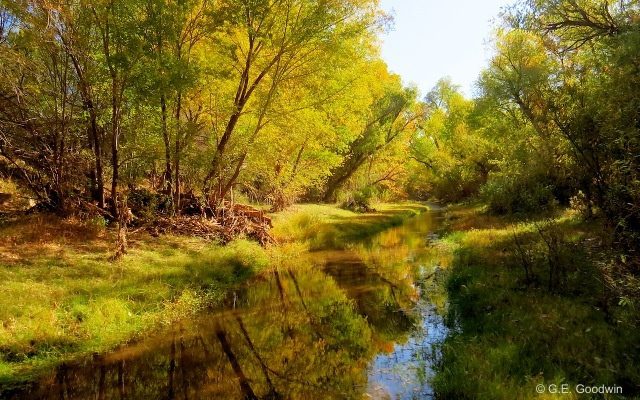
Sonoita Creek, part of the Patagonia Municipal Water Supply
The AZ Mining Inc (Wildcat Silver) Hermosa project is located in the headwaters of the Harshaw creek drainage. When AZ Mining Inc / Wildcat Silver’s first Preliminary Economic Assessment was issued for investors, the project covered about 3,000 acres. The project has since grown to 13,666 acres, and the open pit has expanded by at least 30%, according to AZ Mining Inc / Wildcat Silver’s Pre-Feasibility Study released in December 2013. When Chris Jones, AZ Mining Inc / Wildcat Silver’s then CEO, gave a presentation to Patagonia residents in 2010, he said that the water usage would be 450,000-700,000 gallons of water per day. Estimating water usage from AZ Mining Inc / Wildcat Silver’s own formula and data (one-half ton water for each ton of ore processed), the Hermosa open pit mine would potentially consume almost two million gallons of water per DAY. By comparison, the town of Patagonia uses roughly 115,000 gallons of water per day. Even if everyone in town conserves water by 20%, it amounts to only 23,000 gallons per day. It will have very little impact if these mines go into operation.
These two mines would use close to three billion gallons of groundwater per year. The Town should take a stronger stance on the real threat to our water supply. We can conserve all the water we want, but it would be nothing in comparison to the amount of water consumed by proposed mining.
We live in a desert. We are in a drought with long-term scientific forecasts for increasing water shortages. Water is simply the most precious commodity we have. Water is far more precious than a few jobs promised to us.
Michael Stabile was the chairman of Patagonia’s Planning and Zoning commission, and at present is a Board member of PARA. He worked with Patagonia Town Manager David Teel to get the Sonoita Creek and Harshaw Creek drainages designated as the Town of Patagonia Municipal Supply Watershed.